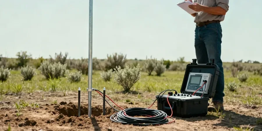
Mesa’s rapid transformation from an agricultural outpost on the Hohokam canal system into Arizona’s third-largest city has placed immense pressure on its subsurface infrastructure. With a population exceeding 500,000 spread across the eastern Salt River Valley, the city’s engineers frequently encounter a complex sequence of basin-fill sediments, caliche layers, and buried paleochannels. Before any deep excavation or foundation design begins, understanding this stratigraphy is critical. The electrical resistivity survey, specifically Vertical Electrical Sounding (VES), allows us to map these transitions by injecting a controlled current into the ground and measuring the resulting potential difference. This method provides a continuous profile of apparent resistivity versus depth, which we interpret to identify the transition from coarse-grained alluvium to finer silts and clays without the need for invasive drilling.
A resistivity contrast of 10:1 between saturated alluvium and caliche hardpan often delineates the drillable limits for standard auger rigs in East Mesa.
Our approach and scope
The Sonoran Desert climate creates unique conditions for geophysical testing. During Mesa’s pre-monsoon summer months, when surface soils become extremely desiccated, contact resistance at the electrode-soil interface can spike, requiring us to saturate the array with saline solutions to maintain data quality. Conversely, the occasional winter rains from Pacific frontal systems can create a shallow perched water table in the caliche hardpan, which dramatically lowers near-surface resistivity and can mask deeper targets if not modeled correctly. Our field procedures follow the Schlumberger array configuration, expanding electrode spacing from an initial AB/2 of 1.5 meters out to 200 meters or more, depending on the target depth. We process the raw data using 1D inversion algorithms to produce a layered earth model, correlating each resistivity horizon with known hydrogeological units from the Mesa basin-fill aquifer system, a critical resource that supplies much of the East Valley’s municipal water.
Local geotechnical context
A contractor excavating for a multi-level parking structure near Downtown Mesa encountered unexpected groundwater inflow at just 12 feet, despite pre-bid logs showing dry conditions to 30 feet. The issue was a lens of high-porosity channel gravel, invisible to sparse borings, that was fed by a leaking irrigation canal a block away. A VES survey, had it been performed, would have flagged this conductive anomaly immediately. Interpreting resistivity data without local geological context invites similar mischaracterizations: a low-resistivity zone might be mistaken for a clay layer when it is actually a saturated, clean sand with high dissolved solids—common in areas influenced by agricultural return flow from Mesa’s historic citrus belt. Our team cross-references every survey with existing well logs and USGS hydrogeologic maps to distinguish lithologic boundaries from pore-fluid effects, ensuring that the interpreted geoelectric section reflects actual ground conditions rather than artifacts of the urban water balance.
Common questions
How much does a VES survey cost in Mesa?
For a typical site investigation in Mesa requiring 8 to 12 vertical electrical soundings with maximum AB/2 spacings around 300 feet, the budget generally falls between US$540 and US$1.120. The final cost depends on the number of soundings, the accessibility of the site, and the amount of surface preparation needed to achieve good electrode coupling in dry desert soils.
What depth can a VES survey reach?
The effective depth of investigation is controlled by the maximum current electrode separation (AB/2). As a rule of thumb, the depth of penetration is approximately one-third to one-half of the AB/2 spacing. With our equipment, we can routinely resolve stratigraphic features to depths of 150 feet beneath the Mesa surface, and deeper targets can be imaged by extending the array, provided sufficient space and power are available.
How does electrical resistivity compare to MASW or seismic refraction?
While seismic methods measure the mechanical stiffness of the ground via shear or compression wave velocity, electrical resistivity responds primarily to changes in pore fluid chemistry and clay content. In Mesa’s alluvial environment, a saturated sand and a dry sand can have nearly identical seismic velocities but will differ in resistivity by an order of magnitude. We often recommend combining VES with seismic methods to create a more complete subsurface model.
Can VES detect the caliche layer under my site?
Yes, the caliche (pedogenic calcium carbonate) that cements the near-surface gravels across Mesa exhibits a distinctive high-resistivity signature, frequently exceeding 1,000 ohm-m. The VES curve will show a sharp knee in the apparent resistivity trend at the depth where the array begins to sense this resistive cap. This is valuable for estimating rippability and for designing pier excavations in the hardpan.
How long does a VES survey take and what access is needed?
A single VES sounding at a Mesa site typically requires 45 to 90 minutes to complete, including electrode layout, measurement stacking to reduce cultural noise, and data quality control. We need a clear, linear spread of up to 600 feet for deep soundings, but the array can be deployed along residential streets, vacant lots, or graded pads. We coordinate with site supervisors to ensure the survey line is staked and free of heavy equipment traffic during acquisition.