ASTM D422 and D2487 define the standard for soil classification in the United States, and nowhere in the Valley is that more critical than on the alluvial fans and caliche layers beneath Mesa. The city stretches across former river terraces of the Salt River, where grain size distribution can shift from coarse gravels to fat clays within a single building lot. Our team performs the full grain size analysis—sieve plus hydrometer—to produce a precise particle size distribution curve that feeds directly into USCS classification. For sites near the Superstition Freeway or out in Eastmark, where desert pavement and cemented soils dominate, we often pair this test with test pits to capture undisturbed gradations from depth. Mesa’s 504,000 residents live atop soils that range from sandy loam to highly plastic clay, and classification errors here can mean the difference between a stable foundation and a heaving slab.
A grain size curve without the hydrometer fraction is a half-finished story—especially in Mesa, where the clay content often controls everything from footing design to drainage strategy.
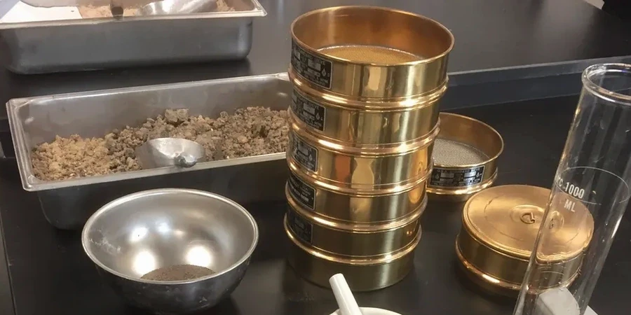
Our approach and scope
Mesa’s arid climate, with just 9 inches of annual rainfall, creates a deceptive surface crust that masks what lies beneath. The upper soils are often wind-deposited silts with low plasticity, but at depths of 3 to 6 feet, residual clays from decomposed basalt flows of the Superstition Mountains can appear. This contrast demands a full hydrometer analysis—not just a sieve stack—to quantify the silt and clay fraction below the No. 200 sieve. Our lab runs ASTM D422 with sodium hexametaphosphate dispersion, measuring hydrometer readings at 15, 30, 60, 240, and 1440 minutes to capture the full sedimentation curve. When expansive clays are suspected, we recommend complementing the grain size analysis with
Atterberg limits to determine the plasticity index, because a silty sand and a clayey sand may share similar gradations but behave entirely differently under moisture changes. The combined data set gives the geotechnical engineer everything needed for a defensible USCS classification per ASTM D2487.
Local geotechnical context
Soil profiles in West Mesa—near the old river channels—tend toward clean sands and gravels with low fines content, which drain well but can be loose and subject to settlement. Move east toward Apache Junction, and you encounter basin-fill deposits with higher clay fractions that swell when wetted. A grain size analysis that skips the hydrometer on a clay-rich sample will classify the soil as a silt, missing the expansive potential entirely. We have seen projects where a simple sieve-only analysis classified a soil as SM (silty sand), but the hydrometer revealed 22% clay fraction, reclassifying it as SC (clayey sand) with significant heave risk. In Mesa’s construction environment, that reclassification changes the entire foundation recommendation—from a standard slab-on-grade to a post-tensioned slab or drilled pier system. The cost of the full analysis is negligible compared to the cost of repairing differential heave across a 2,500-square-foot home.
Regulatory framework
ASTM D422 – Standard Test Method for Particle-Size Analysis of Soils, ASTM D2487 – Standard Practice for Classification of Soils for Engineering Purposes (Unified Soil Classification System), ASTM D1140 – Standard Test Methods for Determining the Amount of Material Finer than 75-μm (No. 200) Sieve, ASTM D4318 – Standard Test Methods for Liquid Limit, Plastic Limit, and Plasticity Index of Soils, AASHTO T88 – Standard Method of Test for Particle Size Analysis of Soils, AASHTO M145 – Standard Specification for Classification of Soils and Soil-Aggregate Mixtures for Highway Construction Purposes
Common questions
What is the cost for a grain size analysis with hydrometer in Mesa?
A complete sieve plus hydrometer analysis per ASTM D422 runs between US$100 and US$220 per sample, depending on whether we are testing a single sample or a batch from the same site. Projects with five or more samples typically qualify for volume pricing. The sieve-only portion is lower, but we strongly recommend the full package for any Mesa soil with visible fines.
How long does the hydrometer portion take?
The hydrometer sedimentation test runs for a minimum of 24 hours to capture the full clay fraction curve. We take readings at standardized time intervals per ASTM D422, and the data reduction—applying temperature corrections, meniscus corrections, and effective depth calculations—takes an additional hour. Combined with the sieve analysis and report preparation, the standard turnaround is 3 business days.
Do I need the hydrometer if my soil looks sandy?
Almost always yes, especially in Mesa. Many soils here appear sandy in the field but contain 10 to 20 percent fines that control the engineering behavior. The hydrometer is the only way to quantify the silt versus clay split, and that split determines whether your soil is frost-susceptible, moisture-sensitive, or expansive. Skipping it on a borderline soil is the most common reason we see foundation problems in East Valley subdivisions.
What sample size do you need for the full analysis?
We require a minimum of 500 grams of dry soil for the full sieve-plus-hydrometer package. For soils that are predominantly fine-grained, 200 grams is sufficient. Samples should be sealed in a plastic bag immediately after collection to preserve the natural moisture content, and we prefer that you deliver them to our Mesa drop-off location within 24 hours of sampling.